Wednesday 27 November 2013

NEW MTB TRAIL-JACKS HILL TO MARYLAND

Courtesy of our friends at “Fun and Thrills’ (thanks Marcus) who have already hiked this trail we decided to give it the explorer treatment.


It is very narrow most of the time, with steep sections and some of the trail “walls” are rock so we can’t hack them out to pass (sorry Kyle)!
There are plenty of little rock drops and tree roots. Boogie rode virtually everything, but I was bouncing too near the edge on my hard tail. This is definitely one for a full “susser”.

There are some nice tight hairpin berms and the best ones near the river are unrideable until we can widen them.

The rest of the trail is high grass, which hides the drop off on one side and at one point both sides.

Of course Boogie was waiting for me at the river, a tranquil spot amid the greenery, to see if I fell in-sorry, not this time!
Then comes the bad news, you have to climb up a twisty trail towards Maryland ( about 15 min). When you come to a little settlement ( Mind Peace) you turn right and go down a stony single track with a little river crossing at the end. Boogie was waiting again, but this time I got my pedal caught in a rock and remounting could line myself up correctly. 


There was more easy downhill and a concrete bridge over the river again with a rail. “Why is Boogie waiting with his camera?” I mused. Almost across the bridge and I saw that it has collapsed, there was a big hole to fall in and an impossible jump unless you had turbo assistance. Sorry Boogie, no paparazzi prize this time!


Finally we climbed up to the road. Verdict, with some cleaning up this is a good technical trail with a full suspension bike, a no-no for anyone who does not like drop-offs."

By David Linehan


View Mind Peace Trail in a larger map

Sunday 24 November 2013

NEW TRAIL-CONSTITUTION HILL TO KINTYRE (PAPINE)


Regular explorers Boogie and David were joined by Keith and Gavin, who was trying his first serious trail.

We rode up to Lindo’s Gap from Liguanea, a 90 minute negative gravity experience, where Boogie punctured twice and I muffed a gear change and fell without damage on one of the steepest bits.

We stopped at the Gap for Boogie to interview a Rasta man for more trail information and spent another thirty minutes uphill to Constitution Hill. It is in fact a Gap or pass with trails in several directions (more exploration to come!).At the village square we had some cold ones, whilst Boogie was interviewing further holders of trail information. One told us it would only take fifteen minutes to get down to Kintyre (actually it took 29).

The trail starts on a narrow tarmac road to local housing and gradually deteriorates. Finally we hit the loose earth and stones and were soon on a single track on the side of the big ridge that overlooks Kingston. At this stage there was a drop off on the right.

We then hit a well defined path but with tall grass making it difficult to see forward. The drop off was now on the right and vertical off the single track. Gavin slipped and fell slowly, fortunately to the left and avoided the big drop. We continued and came to a plateau at the end of the ridge, overlooking Kingston.

From here the real descent started with a narrow rocky single track but not too difficult, although us “hardtailers” had to walk some short bits.

Keith had been complaining of brake fade so he and Boogie swapped bikes: result Boogie with no brakes went faster and Keith with Shimano Saints (the bees knees) felt safe!
Then we met a farmer, (this signified a better defined trail from locals walking it) and the single track became really rideable and fun but Boogie had a puncture on Keith’s bike, so we stopped again.

The trail became wider and we zoomed down some steep slopes to the Kintyre road and back to Papine for breakfast and a cold Red Stripe (Thanks Keith).


Verdict on the single track trail: probably with de-grassing in the middle, most people with full suspension would enjoy it and the “buzz” from the sheer drops on the edge of the tail. It could also be linked up with some of the trails from Flamstead to make a marathon endure/downhill.


Let us also “big up” Gavin who complete what is not the best trail to start with, and no bitching! Congrats Bro!

By David Linehan


View Kintyre Trail in a larger map

Wednesday 13 November 2013

TRAIL EXPLORERS REPORT AND FUTURE EVENTS


Boogie and I went up to Flamstead to check the long trails down to Dallas and the coast, on foot.

The newest, used only once needs some work but Obelix (Boogie) wielding his cutlass and Asterix (David), doing the lighter work, age has its privileges, cleaned up parts, particularly some sharp bends by removing rocks. We need to do some more work but enjoyed the secret waterfalls.


(NB. If you don't follow Asterix the Gaul and Obelix, you are missing a European cult, written in a language that is fun for kids and has sophisticated references for educated adults).
We joined the main trail, known to few, that we fixed up last year and walked up to the top and back to Flamstead Square ( to say I was kn***ered was putting it nicely).

The good news is that it has held up well including our re-engineering and we will have it ready for my birthday ride on 21 or 12 December next, followed by the usual “pot luck” pool party at my place (I supply the alcohol (this year I will have a connoisseurs surprise after the beer and wine has finished, as it always does).

The trail from Belleview to Dallas village is long but not very steep with few technical bits. There are four river crossings and it is single track mainly with a big drop off on the left so speed is to be avoided.


Now for the good news! Before all this Boogie and I explored the beginning of a new trail that goes from Flamstead to Millers Gap. It is not all down hill but the start is spectacular with a single track along the contour lines with regular berms to help the descent. Boogie went back and rode it on Sunday and got from Flamstead to Liguanea in 70 minutes, which means we could ride all the way in about four hours.

Who is up shortly for the latest “real ride”?

By David Linehan

Thursday 10 October 2013

Cascade Trail Revisited!


On Wednesday Boogie, Andy and I revisited the Cascade trail from Holywell down to the road below the waterfall.
We first discovered it by accident whilst having a family barbecue at the park. There was a lady selling bananas and I asked her where she had come from. When she said “Cascade” I said to her “That is a long walk up the road through Section”. “No” she said “I came up the trail”.
Boogies’s ears have an acute extra strength when the word “trail” is mentioned.

The trail starts on the left as you exit the park and is a double track down to coffee farm. Then you turn left on a single track, very narrow and rocky in places with a river crossing. I got my feet wet!

The first time down we christened it the “Hairy, scary trail”. This time we were not so sure it did not seem so bad, until I put my right foot down to push round a rock and there was nothing under my foot! I went backwards over the edge, hung onto a tree and Andy came and rescued my bike. He then pulled me up and I was back on the track and suddenly “edge conscious”. 
In fact after this point there are little rocky bits, which Boogie with his Maxxis tractor tyres and big suspension mainly rode. I didn’t take my downhill bike because of the long climb back from Cascade.

There is then a junction with two ways down, we turned right and the hairy bit began, narrow, steep and several berms that were difficult to negotiate. There is a splendid view of the Cascade waterfall from the trail and then you are on the road to Section. It was a beautiful sunny day with country smells and sounds.

Two of the landslips on the road have been fixed but you still have the single track before Section, which is not so daunting, now the foliage has grown and the path widened.
We stopped at Section to se our Rasta friend and had a French press of really fresh Blue Mountain coffee, for which he charged us 200 dollars.
Suddenly the clouds came down and we did most of the climb to Holywell in the mist but the sun came back as we turned the mountain. Andy and I went to Café Blue for breakfast and Boogie drove off to work (we had motored up to the starting point).


BikeNutz grading? 3 for experience downhillers, 5 for beginners."


Create Maps or search from 80 million at MapMyFitness

Monday 12 August 2013

Kingston is Cool!


Kingston is Cool!

"Kingston is Cool" is my friend David's idea! Is something he is dreaming about for sometime now. His vision is to have some kind of mountain biking event in the mountains above Kingston that would show how much more Kingston can offer for those who love riding and the mountains! Is an idea I liked and supported from the beginning! The fact is that there are so many trails in this area that it would really make sense. First we were thinking of some kind of XC race (cross country) we haven't completely trashed this idea , but lets just say , is not easy to find a completely off-road route especially uphill! Second we thought of a mountain bike marathon, with races of different lengths ("beginner" 15 km, "race" 30 km and "marathon" 50 km) this is something that can work however most of the riding would have to be on paved roads, which doesn't fit in the definition of mountain biking!
What if is not a race, does it have to be a race? What if is a day of fun, of riding together with friends, and what if we skip those long climbs to just enjoy the trails going down?
Oh, I know what my good friend Keith would say: " where is the exercise, I need  the miles to get a good exercise "
Well, when you ride down hill you are standing on the pedals, continuously flexing your knees  absorbing lots of the shocks ( similarly to a skier)  and doing this for hours is guaranteed a good exercise!
So, just before I left Jamaica for vacation I decided I'll do a weekend of downhills and test the idea! Was not the first time we did this but perhaps was the first time to do it for two days in a roll! And let me tell it was a blast!
We started 6:30 am and we went all the way till about 4:30 pm! On the way up we passed the "World Explorers" and " Fun and Thrill" if I am not mistaken, remembering all the effort it takes to go uphill, but "not today"! Today was just for fun!

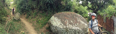
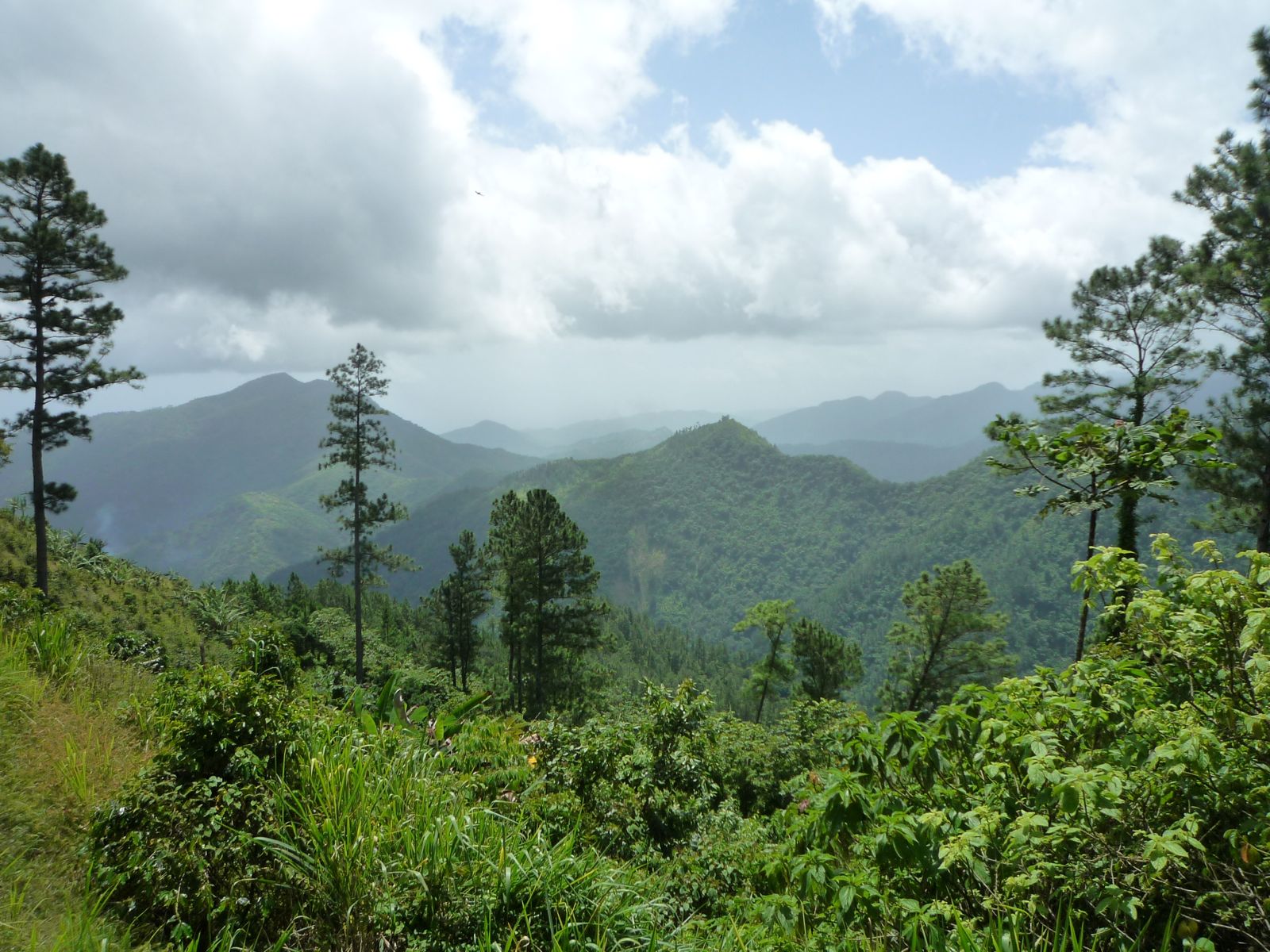
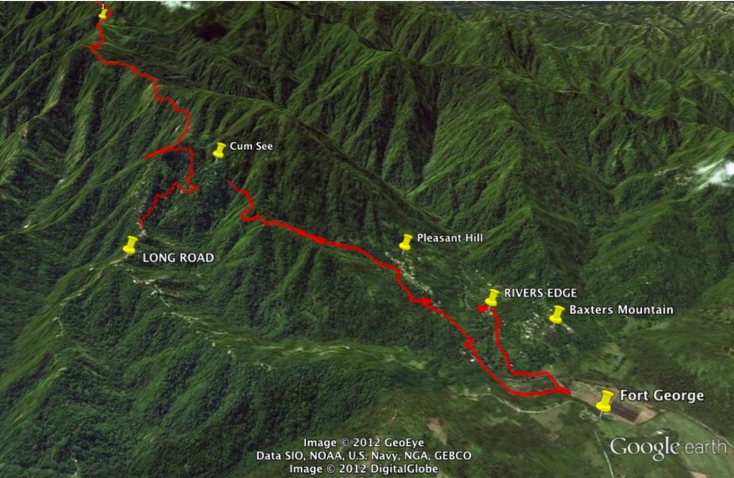
So Andy, David, Marcus and I  drove up to Woodcutters Gap, and descend into Clifton Mount Coffee Farm! What a great place! A beautiful house with a magnificent view over the Blue Mountains , and Catherine's Peak in the background! From here there is a fast and steep descent into St. Peters. We enter the main road right in a deep corner were a few locals seemed happy and at the same time astonished to see us coming from there! One of the man told us he is a rider too and show us his wounds from a bicycle crash, he admitted that some white rum was involved in the story!


From here we ride to Mt Lebanon and Wallenford Coffee factory, here with take our second trail that will carry us across the Yallahs river four times before reaching Roberts Field and the famous "nobody canna cross it" bridge!


Here the vehicle is waiting for us to shuttle us up to Bellevue Great House! ! From here we ride on the Mount Rosanna trail then, Governors Bench trail and Tower Hill trail! The Governors Bench trail is 
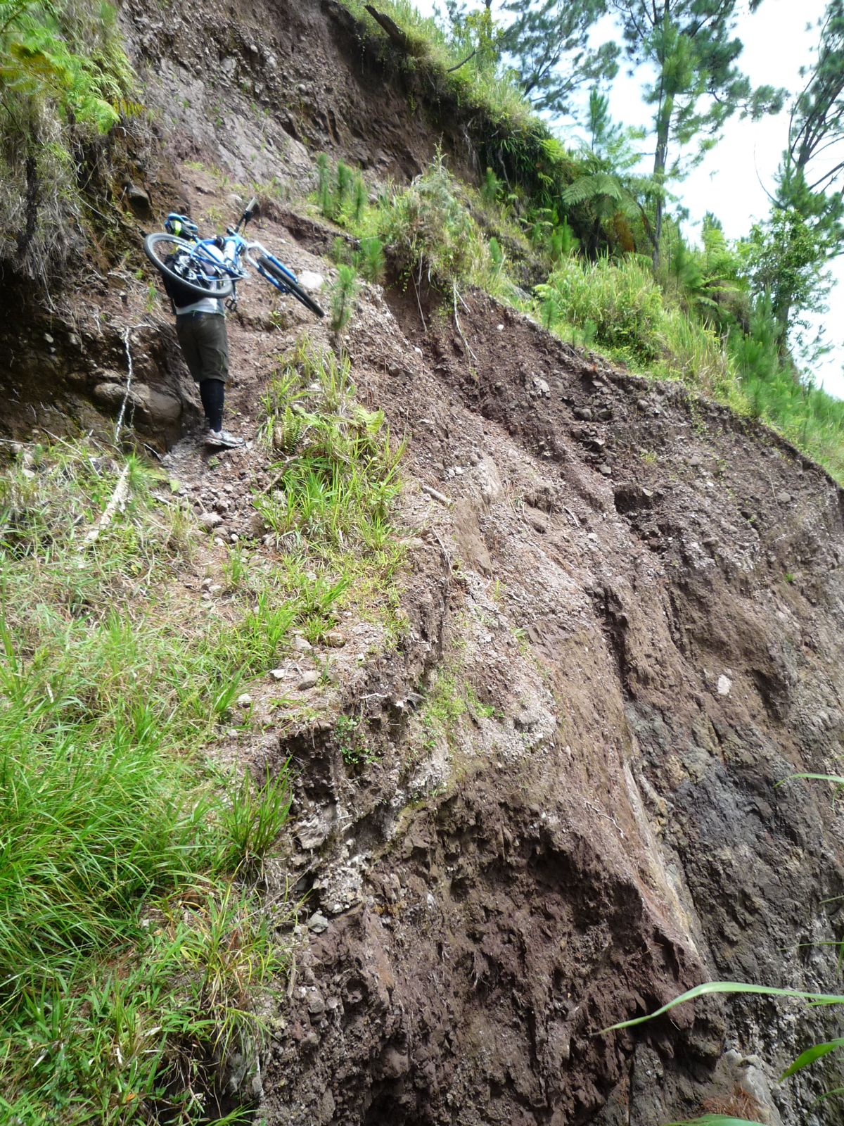
not for the fainted hearted, is very narrow with huge drops on both sides!

  You can see all the way to Cinchona and Blue Mountain Peak on one side and  Bloxburgh, Mount Dispute and Bull Bay, Yallahs on the other! The Tower Hill trail is super fast and fun, it ends in the main road just below Tower Hill!
From here a steep and fast descent into Mavis Bank Coffee Factory for another shuttle up to Flamstead Hill! Here we meet our friend Bradford, a very reliable young man who helps us cleaning and maintaining the trails! We get a short briefing about the condition of the trail after which we dive into Roses Valley. A beautiful trail that passes some lovely pools and waterfalls then a ruin of unknown origin! The trail eventually joins the Money or Boots trail and descends into Dallas and Union Bar. We quickly finish the stock of cold beers, all two of them, so we head down on the road finishing our ride just below Cane River falls. The vehicle is waiting for us with a cooler better stocked than the last bar we visited!
By now we felt really tired after all we did : 7 trails, 17.4 miles of single track with 7614 ft of descent, 10 hrs total time! Great day!


Day 2:
Andy, Marcus and myself,
started in Holywell riding down on the Cascade Trail. I somehow was not sure about the turn off at the end of the trail, so I chose the one that looked the best walked.It turned out to be a trail we haven't rode yet, never the less interesting but chalenging, runing in a deep gully cut by the rain! The trail eventually  disappeared when we found ourselves on a  farm. The main road was not far below, so we decided to "freeride" down the mountain side  down to the main just below Green Hill Post Office! Our friend Buju, welcomed us, he is our local trail builder! We figured out that this was a third version of the Cascade Trail!

We shuttled up to Pads House for the next trail! This is a trail we just cleaned up with Buju a few days before the ride. Nobody rode it yet, so I was really looking forward to try it especially because I knew there were some challenging parts! The top part runs down through the houses, a very fast section. After the last house a nearly invisible right turn takes you on to the real trail! Steep on parts, with steep and impossible switchbacks, certainly with a lot of potential. Everything goes well until I dive into a little step down  and under a fallen tree so I let roll free and hit a stone hidden in the grass! This brings me to a sudden halt, better say my bike! That great feeling of rolling down a steep section ended promptly, I continue through the air, first up, then that feeling of weightlessness that lasted a few milliseconds before crashing down to the ground! Luckily nothing happened so we had a good laugh and continue more precariously!The trail then joins the river and eventually we reach the ruins of the Cedar Valley Factory!  Our driver picked-us up and we head back to Holywell!
 This route is known more as the "Back Road to Holywell! A double dirt track that takes you to Woodford, very fast, and potentially dangerous if you are unlucky to meet with enduro or quad riders flying up the track! It was a lot of fun going down some of the corners have some great berms!
From Woodford a short climb to Happy Gate than down on the trail to Maryland. This is one of my favorites. I use to ride this a lot on weekdays before work. If you ride from Liguanea is about one and a half hours uphill and 30 min back  downhill!  The trail run through an area called Johnny Ridge, a little community that stretches up from Maryland almost all the way to Happy Gate! Is great to ride, you can learn a lot! Every time you ride it you get to do more and better ! This was the case with Marcus who a week before skipped a technical passage, but not today! Well done!

 Next we shuttle up to Strawberry Hill. This is a challenging trail, there is no place for hesitation or mistake on this trail! Is super steep and dusty thus slippery! You literally skidding 50%  of the way down through some steep switch backs. You are controlling the bike through continuously shifting your weight . I hesitated in one corner and went down very quickly, the bike stopped somewhere above me and I rolled down the hill! No serious injury, just shake off the dust and continue down the hill! This is clearly the shortest way to come down from Strawberry Hill (on a trail)!

A climb up Dustry Road  at the hottest time of the day takes us to the next trail! A short climb towards Bamboo Lodge then a left turn on a climbing trail. The end of the trail is a two step drop off in a narrow gully with barb wire on both sides! Andy went down  fairly smooth. My first two or three attempts failed, because I couldn't position myself well and came to a halt almost riding into the barb wire! I eventually managed to tackle it, starting right from the edge! Is a perfectly rideable passage just needs some cleaning, somebody dropped some rubble on it, making it more difficult and slippery!
 After this, Down Pipe Gully 1, 2 and 3! Always fun! Next we meet David at Crystal Edge, we have lunch then decide to do the last trail for the day, Bermuda Mount Trail. I think we all felt tired and had a few crashes by now so we decided to take it easy. There is nothing easy about this trail, rock gardens, steep parts, tight switch backs. We stopped on the way  down, some of the rock gardens were impassable, so we moved a few rocks packed some holes, next time will be much easier and ridable! We ended in Gordon Town and reward ourselves with a cold beer! Totals : 7 trails, 7950ft descent, 15.8 miles, 10 hrs.
Two great days of fantastic riding. Did we do all the trails in Kingston area? Not even from far, I chose, the best and some of the most technical trails in Kingston area, the "crème de la crème"!

 Kingston  has so much to offer for mountain biking, I am glad more and more people start to see this!

Thank you Andy, David, Marcus for sharing this adventure with me!


Thursday 6 June 2013

Rosemount Jazz


June 7, 2013


Ten of of us set for this ride! We meet the "Ochi Crew"(Andy, Kerone, Sanchez) at the round about and drove up to River Edge! We start the ride at 8 am heading back to Fort George than we took a left through the banana fields to Junction Road. After a short ride on the main we turn of towards Georgia Penn and Rosemount. We got admired by some of the villagers who seem to be impressed by our "hard exercise"as they said! It certainly was harder than I remembered! The road gradually got steeper and steeper with some rocky parts as well, testing the riders skills and fitness!

 John, Kerone and Marcus seemed to manage the climb very well so they got well ahead! Keith was doing well just behind them! 

The rest of us Bernadette, Thomas, Andy, Sanchez, Courtney,were going slower , suffering from  the heat, the sun was merciless!
Thats when we had a stop in the shade by this little shop .


Courtney ask me to take a picture of him, before his "DEDO"!


This is one of the last buildings in Rosemount, from here the road turns into a single track undulating through the pristine landscape! A short downhill than a short moderate climb to a spring. Thats where we regrouped with the front riders! Marcus was in the "shower" when we arrived, it definitely cools you down a lot! Is a nice place to have a rest!

From here a short nice  climb to Camberwell main square!  The view is beautiful from here, you can see al the way to Highgate. Everybody decided to ride the Jazzy trail! So there we went. I remembered a fairly short and steep ride up, well, it was not short but it sure was steep!


Eventually we got to the highest point of the ride,  450m (not 370m  as I thought) it felt much higher, after all we climb only 380 m. Thats were the fun started! Downhill time! Andy, Kerone and Sanchez were having fun in Georges Hope square, doing a jump over a big bump than a wall ride! Awesome! 


The downhill was great,  it starts as a nice well running single track then it becomes rougher and rougher! You have to improvise all the time, you try to pick a line but usually it does not work out to well! A continuous rock garden testing your bike to the max! A ride through Ugly River and a slalom through cow pies and mud and there we are at the bridge!
A short ride to River Edge were a cooler loaded with drinks and an awesome Jamaican breakfast  was waiting for us! And a chocolate drink from locally produce chocolate balls!  After breakfast down to Pencar River for a soak!

It was a good ride a true All- Mountain ride ! Bernadette is getting better with each ride! This was Kerone, Marcus and Thomas first ride with us, all did excellent!


Jazzy on Pinkbike


By Bogdan Simandan

This loop is an extended version of the Rosemount Trail! It Starts at River Edge, go to Fort George then to the roundabout , Junction Road, Georgia Penn, Rosemount to  Camberwell  , Georges Hope, now the fun part starts, another 4 km  single track I call it Jazzy! Than back to River Edge, and soak in the river! Phone number for River Edge /Mrs Chuck 3854943.


Create Maps or search from 80 million at MapMyFitness

Wednesday 5 June 2013

Rosemount Trail

This is a nice loop, it starts at the Shell gas station a the round about at the end of Junction Road. The ride takes us through Ft. George, Camberwell, Rosemount, Georgia Pen and back to the gas station.95% off road! 3km single track!

Create Maps or search from 80 million at MapMyFitness

Tuesday 4 June 2013

Cichona/St. Johns Peak

This pictures were taken on a short discovery ride I did from Cinchona riding through St. Helens Gap up towards Sir Johns Peak.It was raining on and off, I felt like in the high european mountains. Gorgeous, peacefull place, extremely humid though! I rode as far as I could, the  track was recently cleared by the forest department, they have a reforestation project in the area. From where the track ended I rode for another maybe 2 min through some big bush then hiked for another 20 min. The trail is walkable but not rideable.I turned back not knowing that I was probably not very far from the peak! On the way back I took a right turn that took me onto a short , exposed and steep single track, dropping me straight into St. Hellens Gap!
I got back to Cinchona were the barbecues were working on full. A cold beer, then some fun riding in the gardens with my daughter! There are some lovely trails through the garden, ideal for teaching beginners! Roots, smal drop offs, berms etc! I spoke with some locals inquiring about trails! I was told you could ride up to a coffee farm than turn right going down to Strawberry Hill and from there down to Westphalia! Perhaps next time!

Tuesday 28 May 2013

Alone on "The Dark Side"

I am passionate about the things I do! I did and tried many different sports and adventures. I was competitively swimming, playing basketball, caving, rock-climbing. I loved and still love kayaking, white water kayaking, skiing, mountain biking, sailing, hiking! I know this mind sound like a lot of things and may make you wonder how somebody would have the time to do all of this! Well the
answer is simple: you don't have the time, unless you are some kind of professional outdoor guide or something like that! One thing is for sure, when I'm passioned about something I put all my energy into it! Once the passion is gone I am moving on to something else! As a child I remember being told that I start doing sports or hobbies and then I abandon them!  I was expected to do something for  a lifetime ! Well, I guess I was just searching , trying things, looking for what I really like ! After all we should enjoy  what we are doing otherwise what is the point lof doing something!

Bike riding and hiking  is  some of those things that are keep coming back in my life, and I think, it actually has to do with my love for nature and especially mountains! I started hiking when I was 5 years old, going to over 2000m high mountains! This had a very strong impact on all my life. This is one of the oldest memory I have! I remember walking down from the high mountains and I was exhausted, probably beging my parents for a ride on their back when this huge white dog showed up on the trail! I was mesmerised, I immediately started to play with him and run after him all the way to the cabin.
After this period  my parents started to do more fishing trips, especially on the nearby Mures river. Basically I spent nearly every weekend sleeping in a tent on one of the islands of this river. I loved it, I was fishing, swimming, watching birds and animals just exploring everything! It was probably the best period of my life!

About 10 years past until I get back to those mountains, but now with my friends, as a skier, as rock climber and a hiker.  It was fantastic to rediscover those mountains again. I was around 16  then, nothing seemed impossible! I was testing my limits. I very quickly learn to respect the mountains, I was looking at them like to a living creature! I learn that I am just a tiny ant, compare to them and that I am completely at their mercy! Around that time I got my first mountain bike which in those day in Romania was still a rarity! It was amazing, the idea that I can go on my bicycle where it was never imaginable before absolutely thrilled me! Even if the bike was not a very performant bike I was doing some of my best rides ever! This was a time of learning, I was learning with the method of trial and error, sometimes hurt! Later on when I started working I  could afford a better bike.And Man! what a difference. Finally I head a front shock, I was able to change gears  when I wanted to, stop when I wanted!
I was riding with my friends all learning from each other, youtube did not existed then!

Well I actually sat down to write something about my solo ride across the Dark Side trail, one of the most remote off-road trails in Jamaica, instead I almost  ended writing my biography! I wanted you to understand what is my background, where I am coming from! Some people think I am mad to do a ride like this alone, for some might be normal! For me is not a big deal, doing all this sports I learn to know my limits, and I learn that on ride like this you have to be prepared for everything. What do I mean everything:
  • What if the weather is changing dramatically in a very short period of time! I was prepared with rain jacket and dry clothes !
  • In case of heavy rains the trail might become impassable, due to landslides! With this my hiking and climbing background helps!
  • What if the bike brakes down? I have sufficient spare tubes and some crucial parts, and mechanical knowledge to be able to fix almost anything on the bike!
  • What if something brakes and you can fix it? It can happen, then i put the bike on my back and walk, I walked this trail before I know it well!
  • What if you fall and get injured? That is always possible, thats why in cases like this I ride 10 times slower and I am very cautions not taking any risks and always wear protection!
  • Is not a good idea to go alone, what if somebody robs you? In Jamaica robberies occur mainly in the urban environment,  country people are very nice people! I met two persons on this ride both of them asked me if I am alone! I said: No Man! Whole leep of people behind, them just slow, they might not make it though !
  • I am always prepared to spend a night in the wild if I have to, and on ride like this I always carry a head light!
About the ride now!See Davids description of the trail here!
 It was very smooth everything went well, I finished the climb in 1.5 hrs. Being alone I didn't have to wait for anybody, I made about  four short stops not longer then 5 min. Its a challenging climb with slippery rocks, but you also have nice stretches with moderate climbs where you can recover! This road goes through some pine forests at the end of the climb you get to a large coffee farm! You pass an unfinished concrete building on your left then a wooden cottage on the right! The descent starts from here first on a double track then gradually changing to a single track! The track is almost always wet and slippery! You pass a small waterfall on your left the locals call it "The Fridge" that is the source of water for the coffee workers! The water flows on the track , it washed all the soil away leaving an interesting rock bed! The stream leaves the road at the first ( the bigest)landslide! It seems to get bigger and bigger each time, you have to climb higher and higher to avoid it!

After this you are on a very nice single track that seems to never end. It is very narrow, I mean  some places about 1/2 foot wide. The challenge is to stay on it , because you have fairly tall grass on both sides of it, wich can hide holes, ravines, stones, trees or whatever else! Otherwise there are no technical parts here! A lots of trees  fallen over the trail, some you can jump some you have to climb! Next you get to a nice clean area where you have some coffee bushes on you left!

The trail runs on a ridge from this point, nicely undulating until you get to Mas Loyds shed wich is built right on the trail! I always stop and have a chat with him! From here is all downhill to "Cum See", here you can hear the music from the village and you have at least there different ways to get to Long Road!
Non of them is easy , they are steep and technical with a lot of debris on it! I took the left turn here then about 500 m later a steep right turn. This took me to a blue concrete 2 story  house! The view is fantastic, you can see all the way to Robins Bay! After the house the right turn takes you into Long Road, from there on a terrible condition  main road you can get to Fort George and Annotto Bay.

However I took a left turn at the house, this extends the trail with another 5 km dropping you to Pleasant Hill! The trail was very over grown extremely hard to ride and because of this not really enjoyable except the last 2 km which are awesome!

There is one thing everybody need to know about most trails in Jamaica. They are foot paths use by locals to get to their farms or from one village to the other, they are the only one who maintain them but usually just as much as you can walk through! Due to the tropical climate everything grows very fast, therefore what you rode today might not be ridable in a month time! We explore all this trails always hoping to find a nice ridable trail , and we always hope that the locals are keep using them as well. The truth is, that there is an older generation, who still farms up in the mountains in places that in the past use to be an easily accessible community! Most of this communities dont exist anymore, only the older one are still farming there but usually they moved closer to the main road. Unfortunately when this generation dies out or gives up farming this trails are going to become overgrown, unless somebody else takes over. The younger generation is not interested in this hard type of work! Our intention through this forums is to publish all the trails we know, with maps and access information, so that as many people as possible will use the trails. They can be used by hikers, bird watchers or anybody else!
Our intention is also to promote All-mountain trail riding, right now there is a growing number of people who ride mountain bikes in Jamaica, but only a very small number of people  are interested  trail  riding!

I made a video about the ride, is rather long and boring but the purpose of it is not entertain but to document, and record the trail!

By Bogdan Simandan

The Dark Side Trail on Pinkbike

Create Maps or search from 80 million at MapMyFitness

Create Maps or search from 80 million at MapMyFitness


Monday 6 May 2013

The North-West Passage


The name “North West Passage” comes from the efforts of sailors to go from the Atlantic to the Pacific through the Bering Straits between Russia and North America. This was a vain effort because the seas were always ice-bound.

Our Jamaican MTB equivalent is in the mountains above Mount Airy, trying to find a way through this remote area. John Richards, Amador Gilman and I tried three years ago and explored many tails, coming to dead ends or impassable landslips.

Last year Boogie and I tried it in the opposite direction, Mount Airy, Wataru Coffee Farm, over the ridge and on to the Leith Hall Gap trail and thence back to Mount Airy, showing that the area was not impenetrable. Apart from the stiff trail climbs on dirt and one bushy section we succeeded. See the 2012 blog HERE!

This Sunday we invite anyone to join us on the 3-4 hour ride, in the original direction and Keith, Mark, Paul, Bernadette, Boogie and myself set out form Mount Airy.
The stiff climb to Mount Cressy was even harder after the recent rain and we then turned left toward Leith Hall Gap on what as supposed to be a gentle climb. This was wet and muddy but rideable until we reached the latter part of the climb. Hurricanes and landslips had wreaked their havoc and the wide double track was a genuine single but very broken up and we had to climb over many fallen trees, until we reached Leith Hall Gap.

This should have been the end of the venture but as the descent seemed passable we continued but soon were climbing over fallen trees again and riding on a single track in high grass, mainly uphill. We eventually reached the little trail that takes you to the ridge and down to the coffee farm. This was rideable in high grass but frequently blocked by trees. Boogie did some sterling work with his machete.
We proceeded down the trail and experienced the strange feeling of riding on a single track in high grass so you could not see what was coming.
This was completed and we arrived on a small plateau overlooking the valley, where a wide but stony track takes you steeply downhill to the river. Bernadette was unfortunate to meet some deep mud on a corner and ended up sitting in it, again she refused a photo call!
Finally we arrived at the river crossing and Bernadette could not wait to get wet, falling in, bike, luggage and all. The gentlemen this time were polite and did not ask for a rerun to film. We disported ourselves here for some time, Boogie and I were quiet about the climb out of the valley and the same stony track, very steep in places and even with a granny gear there was no passing this test. However we all made it and collapsed on the tarmac so close to Mount Airy and the landslip barrier. We were advised to take the dirt road that went round it, but one look at the steep gradient was enough to send us up the tarmac road to the landslip.
Boogie and I had crossed it before, the locals having built a stairway of sorts, or rather Boogie took the bikes over and I shuffled across, without looking down at the enormous chasm below.

Bernadette set off first and got half way up the steep side and then over the top and down with some help from Boogie, who then turned himself into a super-porter to help us, including scairedy-cat me!

Never again!

We finished the climb and descended to the vehicles at Mount Airy although Boogie and I rode directly into the bar and our combined order of “cold ones” cleaned out their stock!


Conclusion: congratulations to all who made it, Bernadette and Paul particularly and Boogie for his tree felling exploits. However it is a pity that such a lovely and challenging trail is now really to be avoided, unless in the unlikely event that the Forestry Department cleans it up.


However we have other trails in the area, watch this space!


North-West Passage on Pinkbike MAP


Trail Map Courtesy of Bernadette

By David Linehan

Follow us also on Facebook and Gravity Jamaica!

Wednesday 1 May 2013

THE MACCA MASSACRE ON THE COPTIC TRAIL


Bernadette (resplendent with new full “susser”), Mark and Keith joined us for a revisit to this newly found trail.

We started in Yallahs with the tough climb of more than an hour to the summit and took time to climb yet higher to the magnificent view site.


Then we began the trail and poor Bernadette christened the new bike with a tumble. We asked her to go back and do it again so that we could take photos-no luck!

We then began the stony descent from the ridge and had a couple of missed turnings before we came to the Bamboo Avenue, which is pretty and fun to ride.

Keith then had a flat and we found the alternative way down which was too rocky but eventually after a stiff climb arrived at the Coptic Church and met our Granny friend and the little boy from our previous blog. A few pictures and granny gave us two bags of mangos and some guidance for two ways down.

We chose the “road” which was clear but with plenty of the dreaded macca bushes. Boogie has already flatted with his auto-repairing tubeless and then it was Mark’s turn. I passed him and started a fun descent but the front felt heavy and taking a bend I lost it and ended up, totally upright in a macca bush and another front flat and a slow rear puncture. By this time Keith had flatted again and we stopped to repair a dozen or so flats (no exaggeration) between us and remove innumerable macca thorns.

I went down to scout the trail and followed the well-worn part, whereas the others went straight on.

Comedy, I did a circuit of the village after White Horses on a flat back wheel. My last tube being already punctured and the others were farther down the road. I was trying to ring Boogie when a pick up stopped and asked me if I needed help!
It was Howard our friend of “Fun and Thrills” on non-bike duties. I put the bike in the back and we passed Boogie and Mark riding towards Yallahs, then we picked up a walking Bernadette who had punctured again! Meanwhile Keith had ridden like a demon to catch me, thinking I was in front!

Moral of the story, I broke the rules by separating from the group and then we all split up. Thanks to Howard we were saved.

So Boogie and Mark were in a bar somewhere near Yallahs, Bernadette, Keith and I were having a cold one at a gas station opposite where our cars were parked.

Mark had two more flats where he stopped, he had already been patching patches!

Conclusion: don’t break the rules, then like the marines we all come home and the new trail was great, but for the macca thorns.

Just for those to think you have to have a super MTB for these trails, Mark was on a classic Giant with no suspension and rim brakes. If you have full suspension and hydraulic brakes you can go faster and it is more comfortable, but you can still enjoy the ride.

What is the next challenge? Boogie has found a new way from Flamstead to Dallas and the coast. He swears there are no macca bushes. He also told us a story about finding a skeleton once: no NOT a brave MTBer in Jamaica, it was a prehistoric one back in Europe!

Coptic Trail on Pinkbike


Trail Map Courtesy of Bernadette


By David Linehan

"Bamboo Shots"


This are pictures from a 2 day ride we did, which represents the southern leg of our "Tour of the Blue Mountains". We explore it, bit by bit before we do the whole ride. The exploring is made difficult by the relative big distance and accessibility from Kingston.The idea is to be able to do this ride unsupported as much as possible off road and have some cool single tracks in it!
Day1
 We left Kingston 5:30 am and get to the trail head at 10:30 am. Riding through: Guava Ridge, Mavis Bank, Mt. Charles, Hagley Gap, Ness Castle, Bethel Gap, Belle Clare. I research thoroughly the area and get as much information I could, load the single track on the GPS and still when we got there it was very hard to find the trail head. Maybe because just simply it was not there! But with the help of the local farmers we got some directions and still take a wrong turn.Luckily we met a farmer in the bush who gave us some directions:(' climb back to the main road and take the next left turn or follow a track that connects to the main trail") . We asked if there is any other turn we should be aware, he said: "No just follow the track" Cool, I taught! So we follow the track until we saw three trails branching off! Sh..t! Non of them was going close to my GPS track! Just when we thought we will have to push uphill to the main road we found a shack and a Rasta Man, we were happy to see him and he must have been a bit shocked to see two "White Man's" in the middle of nowhere with bicycles! With his help we found the right track which proved to be very nice , with difficult rock gardens and sweet switch backs. As we got close to the Mount Vernon the trail was running in a dry river bed with big stones, was fun , you could choose different lines, through or roll over with some small jumps! It was there that we started to hear "Gun" shots. We thought are hunters, maybe shooting for birds or wild hog. We were coming form the bush, so it was not irrational my friends Tony 's nervousness! He ask me if we should continue, my answer was simple " do you want to climb back up"! So we continued and shortly after we spot the first house!Here we inquired about the "hunting", a smiling face assured us we are safe is just bamboo burning! I always heard stories about burning bamboo and the explosion sound it makes, experiencing it, really sounds like gun shots! People from Mount Vernon were very nice, where very surprise to here we rod down the trail! I think the name choice for the trail was easy: "Bamboo Shots" 3 km long! So we have another single track trail, as most of the trails, is walking trail, no work was ever done to make it more rider friendly.It could be an awesome trail, hopefully one day the "Kingstonian" Mountain Biking community will do more mountain biking than "Road Mountain Biking" and will discover the beauty of the unbeaten tracks, and the huge potential this country has for mountain biking! It takes a group effort and dedication to build single tracks, Andy Giles and SMORBA, proved it already doing a fantastic job in St. Mary! BIG UP!


Day 2
 Our friend Wayne drove down to Whispering Bamboo, and join us for the ride!
Plan was to ride straight through Needdham Pen, Cory Hall ( locals called it "Broxton") Wilmington , Frienship to get to Ginger Hall where a hard 4 mile climb was waiting for us! As  almost always what looks like an easy ride on the map and Google Earth it turn to be a very steep climb, it was only 300 m elevation, but I always seem to forget that we start literally at see level. And the heat, those who been in Jamaica know what I am talking about. The views were fantastic we saw a ruin of an old wind mill, unfortunately to far to get a good picture of it. Than we finally reach the top, well the first top and then the next one and the next one and the......! Very interesting landscape  worth some more exploring , it would be a good area for some cross country mountain biking!
From Willmington a fast downhill to Friendship, cross to Ginger Hall and then climb and climb and when you think you are there you hit the steepest part of the climb. You literally you have to touch the handle bar with your nose to prevent your front wheel from lifting of the ground! And finally there!
We had a cold beer by Mr. Anthony's shop, have a little rest and talk with our local friends before we headed down!
The downhill was super fast and fun even though it was on a road, partly unpaved! We decided to ride through Airy Castle and Port Morant. We stopped in Airy Castle for one of the best jelly I ever had.
Our friend Rudi provided this delicious treat for us! We and the local crew, were all entertained by Tony's  way of eating the jelly out of the coconut.What can I say: "Tourist"!! After this, a nice downhill into Port Morant than follow the coast road back to the hotel! Drive back to Kingston!

 It was a great weekend!

by Bogdan Simandan (Boogie)

Sunday 7 April 2013

THE COPTIC CHURCH


Here is a “real ride’ in Bikenutz terms, for climbers and descenders.


The Climb:Boogie explored it with Wayne, on a motor bike and mapped and photographed it. It begins on the eastern exit from Yallahs with a sharp lef turn and a 10% tarmac gradient that does not let up for nearly and hour. It is being surfaced but the top half is still stony marl and needs the “granny” gear, or a good warm up before you start.

There is a great view of the Blue Mountains at the top and a rocky descent and further climbing to the beginning of two trails, near an abandoned car and before you go up to the signal tower above Yallahs. Riding time, at least an hour and a half.

“Real Riders” can do the climb and then tackle the descents as we did.


The Descents: Once you take the single track on the left it is easily rideable, other than passing a barb-wire fence. You then arrive on a plateau, with two choices.


Option one-along the ridge:

Boogie and I took this and did some clearing of bamboo and de- bushing but halfway to the house we could see (this means a trail down) we realized there was too much clearing work for that day and retraced to the plateau. We will go back and find the descent to Rozelle.


Option two-the Coptic Trail: This is a wide trail on the right on the side of the ridge, with only a single track rideable and plenty of rocks that used to form the base of the wider trail.

This means that the whole single track is an Andy Giles Carlton Pass style rock garden. I managed it on my hard tail bike, but a full-susser would be better. The legs as rear suspension took quite a beating.

It is not too steep but we will need to go back and mark the deviations from the wide gully track that is blocked in places. Locals have walked by-pass route that we managed to find, save one.


We enjoyed some newly fallen mangos but missed a turn, so Boogie had to do some machete work that brought us to a path and what seemed like civilization.
 

In fact we arrived at the still inhabited ruins of one of Jamaica’s Coptic communities. They are famous for the wrong reasons- see my footnote. The church in the circular style of the Thorn of Crowns is the centre piece for the ten souls who still live there.


We talked to Granny Iris and were told to follow the trail straight, don’t take any turn offs. Back to the rock gardens and a fallen road bridge over the river. Fortunately it was dry and with Boogie’s help I managed to climb up the opposite bank and saw a mirage- tarmac!


It was a disused road in perfect condition. Downhill and we saw the sign-Coptic Road. Turn right and continue downhill on a normal Jamaican road with jumps and holes and you come to the last corner on the uphill main road at White Horses and Audrey’s East End Bar with cold beverages.

Mission accomplished!


 Footnote:

Ethiopian Zion Coptic Church From Wikipedia, the free encyclopedia

The Ethiopian Zion Coptic Church is a mansion of the Rastafari movement that flourished in the 1970s in Jamaica and was incorporated in Florida in 1975. Members of the movement say it is based on the teachings of Marcus Garvey and that they use cannabis as the Rastafari sacrament.[1]

In 1979 the group was accused, tried, and convicted of smuggling massive amounts of potent cannabis from Jamaica to Miami in actions that kept the Jamaican economy afloat that decade. The incumbent Jamaican Prime Minister Edward Seaga told a U.S. interview "It's just a little sin semilla that it keep the country going right now". The Coptics published a free newspaper promoting Garveyism and the decriminalization of marijuana. They were also featured on a sensational episode of 60 Minutes on October 28, 1979. The group's leader was Thomas Reilly, also known as Brother Louv. In 1986 the organization participated in the Drug Enforcement Administration's hearings on cannabis rescheduling in the United States.

On August 8, 1994 Jim Tranmer, a former member of the group, wrote a letter to Carl E. Olson while meditating on his 35-year prison sentence and his departure from the EZCC's "malicious hierarchy".

The EZCC is not associated with the Coptic Orthodox Church or the Coptic Catholic Church, both based in Egypt. The Coptic Orthodox Church has an Ethiopian sister church, which is also unrelated.

The Zion Coptic Church was featured in the 2011 Billy Corben documentary Square Grouper: The Godfathers of Ganja, whose first section concerns the group and features interviews with former members.


Also see below a video about the Coptics, showing images of the place from 1979!


By David Linehan


Create Maps or search from 80 million at MapMyFitness